High-frequency geophysical radio wave sounding equipment GEOScanner-RF
High-frequency geophysical radio wave sounding equipment GEOScanner-RF is:
- speed and reliability of express analysis of the geological structure at depths up to 50 m and more;
- high-precision determination of the coordinates and depth of the aquifer;
- search for voids of natural and artificial origin in the ground;
- control of the condition of soils and embankments under the railway bed;
- control of stress-strain conditions of tunnels, bridge supports, natural - study of
soils for industrial and civil construction, control of deformations of underground and ground parts of buildings and structures;
- assessment of the conditions of runways, road surfaces, overpasses, overpasses;
- study of deposits of solid minerals of all types, including placer;
- study of areas for the disposal of industrial and household waste with in order to preserve environmental safety;
- determination of ways of spreading industrial pollution of territories (soils and waters).
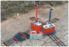
THE WORK IS CARRIED OUT WITH A GEOSCANNER-RF KIT. WITH A HIGH LEVEL OF RELIABILITY, OUR TECHNOLOGY REDUCES COSTS BY A FACTOR OF 10-15 COMPARED TO CONVENTIONAL GEOPHYSICAL SURVEY METHODS.
The final result of the radio wave sounding (RWS) work is a map (cross-section) of the studied area (site) with a detailed and highly accurate indication of the depth and thickness of water horizons, voids, weakened zones affecting the quality condition of road and railway bed sections, runways and other objects under study.
The work is carried out on the surface in a non-contact, environmentally friendly way using a Geoscanner-RF instrument.
")
")